My mother recently planned a two-week photography adventure vacation to Kenya for the Great Migration—a vast yearly movement of wildebeests, gazelles, and other mammals from Tanzania to Kenya—starting five days before the unsettling presidential election. With images of violence that followed Kenya’s last election, I asked my mother if she could cancel her trip. "No one will be able to find you if you get stuck in remote wilderness areas,” I told her. “What if you are confronted with agitated crowds flowing out of the cities? What if your team needs to evacuate for some disastrous events? What if there is a breakout of an epidemic?"
My concern for my mother’s safety stemmed from my fear of potential catastrophe in Kenya. I worried not only about the behavior of citizens after the stressful election, but also about how capable the local authorities might be of dealing with such agitated citizens. Few can tell what is going to happen in a rare, critical event like a natural or human-made disaster, when troubles come at an enormous scale and everything can break down. In cases like these, proper and timely intervention can be lifesaving. Therefore, policy makers are supposed to put disaster management and emergency planning on their to-do lists, side-by-side with boosting economic growth and promoting social justice. Preventing bad is as valuable as doing good.
But what do these policy makers need to consider during critical events and emergency situations? First, if it’s possible, they must give early warnings and maintain communication with the public so that the society as a whole can stay organized and be prepared. Moreover, they must allocate their limited resources appropriately and deliver resources efficiently. They also need to monitor public health: they must work to prevent an outbreak of disease and avert the spread of uncontrolled panic or violence. Finally, policy makers must consider recovery and understand how to rehabilitate crippled communities to get back to their normal functions.
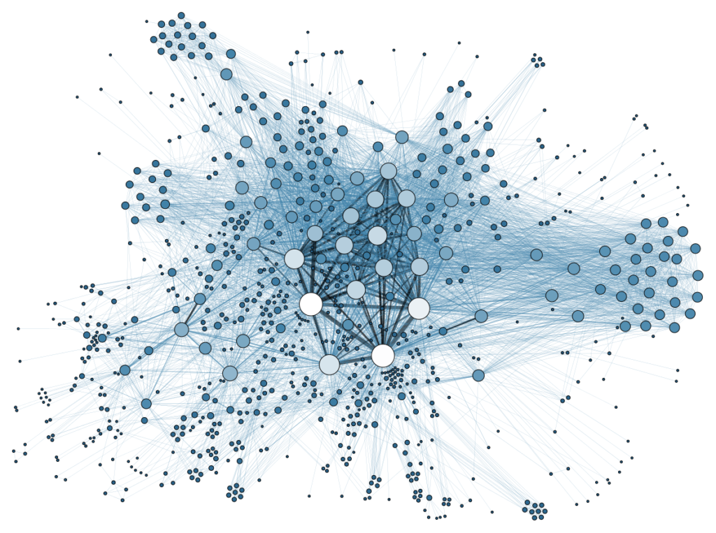
All of these considerations require real-time reliable information, which is not always readily available to policy makers. Even very basic information, like how severe the damage is, how the affected population moves, or how people seek support, is often out of reach. Therefore, academic researchers are finding an increasing need to lend their support to the accessible mobile data cause. By providing useful and accessible data, researchers can help government officials locate damaged areas, efficiently assess needs, and allocate resources during disasters.
After the 2010 earthquake in Haiti, Digicel—one of the two major Global System for Mobile communication operators in Haiti—collected and shared mobile phone network data with researchers. Dr. Linus Bengtsson, junior faculty in the Department of Public Health Sciences at the Karolinska Institute in Sweden, led a research effort to use these data to estimate the trends of human mobility in and out of Port-au-Prince, the heavily affected capital. Bengtsson and his team tracked the location and movements of mobile phone holders by determining the mobile phone tower through which each mobile phone’s SIM card is connected. They were able to apply their method right away (faster than the officially published alarms), and their information was instrumental in helping to control the cholera outbreak that followed the earthquake.
To better understand the issue of malaria transmission in Kenya, Professor Amy Wesolowski at Carnegie Mellon University and her colleagues combined human mobility information derived from mobile phone data with detailed location data of malaria cases. Wesolowski’s research team used these data to map out the travel patterns of nearly 15 million individuals over the course of a year in Kenya and compare it to malaria prevalence information. From there, they were able to create a transmission model of malaria and show possible paths by which malaria spreads. By identifying the sources, sinks, and routes of infections due to human travel, their findings could greatly improve malaria control programs.
Beyond location information, temporal data can also convey messages about human behaviors in disasters. For example, in a project led by Professor Xin Lu from the Karolinska Institute, researchers constructed a space-time distribution of cyclone impact as a storm moves across the affected region. To do so, they used calling frequency and mobile recharge purchases. The former revealed the most affected days, while the latter told a story of people’s preparation for the storm in vulnerable areas, because as the affected people planned for the need to communicate with family and friends, they recharged their mobile phone minutes and data ahead of time, causing a surge in purchases.
Location and temporal data can also provide insight into interpersonal interactions, which can uncover hidden patterns of social behavior in groups. Professor Joshua Blumenstock in the School of Information at UC Berkeley and his colleagues gave a spectacular illustration of this. The researchers wondered whether a person’s informal risk-sharing network—the people or institutions a person connects to when in need—could help this person survive in the face of economic shocks. For example, could a person whose home was destroyed in an earthquake leverage their social connections in order to buy food, medication, and materials to rebuild their house? No good data were available for testing the hypothesis until 2008, the year a large earthquake in Rwanda caused people in unaffected parts of the country to transfer a rudimentary form of “mobile money,” which is dollars transferred via mobile phones for a small cost, to people living close to the earthquake’s epicenter. Blumenstock and his team found that: wealthier phone users are significantly more likely to receive a transfer after the earthquake; individuals with a large number of contacts are more likely to receive transfers on normal days, but are not more likely to receive transfers on the day of the earthquake; and transfers are more likely if the recipient has previously sent money to the sender. In summary, the researchers found that a person is more likely to send a mobile money transfer to someone they know, to someone who has sent them money before, or to someone who lives geographically close. A person sending a mobile money transfer tends not to be motivated by pure charity or altruism.
Every year, hundreds of millions of people worldwide suffer tremendous losses from human-made and natural disasters. The availability of timely information, such as data about the movement and communication behaviors of disaster-affected populations, greatly facilitates emergency response efforts. Mobile phone usage provides a wealth of data to reveal new, real-time insights about human behavior during such critical events. Mobile phones generate data about our everyday activities, and these data are created at a high frequency and low cost. Moreover, mobile phone data are difficult to artificially manipulate and contain enough rich information for researchers to identify patterns and draw insights. Using mobile phone data, we may open the door to more efficient and effective policy interventions.
After sharing all of this information with my mother, she eventually decided to go to Kenya for the trip. By keeping her mobile phone with her at all times providing her with real-time data continuously, she believed she could sufficiently manage her risk. While my mother’s assumption is not entirely valid at this moment, mobile phones are becoming increasingly useful in managing and navigating disaster risks. For my mother—and for anyone else who may be affected by disasters—to remain as safe as possible, governments, policy makers, and relief agencies would do well to make better use of mobile data.
Featured Image Credit: Martin Grandjean


